Difficulties in initializing different GIS layers with ESRI

Hi to GIS community,
I am a GIS engineer and facing some difficulties in initializing different GIS layers with ESRI.
When I try to add different layers on a GIS map, I get the following error on my screen:
The error says:
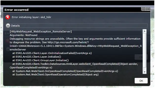
Error occurred Error initializing layer: skd_hilir
Details
[HttpWebRequest_WebException_RemoteServer]
Arguments: NotFound
Debugging resource stings are unavailable. Often the key and arguments provide sufficient information to diagnose the problem. See http://go.microsoft.com/fwlinkl? linkid=1066638Wersion=5.1.10411.0&File=System.Windows.dll&Key=FIttpWebRequest_WebException_R emoteServer
at ESRLArcGIS.Client.Layer.OnInitializationFailed(EventArgs e)
at ESRLArcGIS.Client.Layer.Initialize()
at ESRLArcGIS.Client.GroupLayer.Inifialize()
at ESRLArcGIS.Client.Toolkit.DataSources.Km1Layer.webclient_OpenReadCompleted(Objett sender, OpenReadCompletedEventArgs e)
at System.NetWebClient.OnOpenReadCompleted(OpenReadCompletedEventArgs e)
at System.NetWebClient.OpenReadOpentionCompleted(Object arg)
I have searched a lot about how to get rid of the problem but still can't get to the root cause of the problem. If anyone can help me resolve the issue, I'll be really obliged.
Looking forward to an early reply.
Kindest regards
abram


